30 Percy Road London E111aj


des
| Enviroment Warnings | Current | Potential |
|---|---|---|
|
Very environmentally friendly - lower CO2 emissions 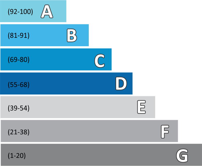
Not environmentally friendly - higher CO2 emissions |
| Energy Efficient | Current | Potential |
|---|---|---|
|
Very energy efficient - lower running costs 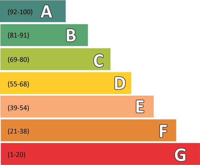
Not energy efficient - higher running costs |
Summary
remarks
special conditions
| Available From | 15/12/24 07:40 | |
| Property Type | Apartment | |
| Ground Rent | £ 6,000 | |
| Total Area | 5000Sq.feet | |
| Local Council Tax Band | A |
| Contract Terms | Sole Agent |
| Rent To |
|
| Local Council | London |
| Cross Streets | Nordoff |
| Floors | Carpet - Ceramic Tile |
| Plumbing | Full Copper Plumbing |
Home valuation estimated for properties within a 1.86 miles radius for postcode E11 1AJ, considering below listed build quality and infrastructure features
| Rooms | Living Room> | Parking | Outside Space | Finish Quality |
|---|---|---|---|---|
| Double shared bath : 1 Single shared bath : 1 |
Yes | Yes | Yes | Average |
Details of the property purchase cost, house development expenses, and nearby comparable information
All amounts are in £
| Purchase Price | Stamp Duty | Legals |
|---|---|---|
| 1,000,000 | 71,250 | 5,000 |
| Demolition | Refurbishment | Architects | Construction |
|---|---|---|---|
| 0 | 246,000 | 60,000 | 300,000 |
| Rating : Very good restaurant hygiene | Process Time : 0.93 | Proportion Bad : 0 |
|---|
| S.No | name | Hygiene Rating | Distance in Mile |
|---|---|---|---|
| 2 | WF Catering at Gwyn Jones Primary & Nursery School | 5 | 0.10 |
| 3 | Outlook Care | 4 | 0.10 |
| 4 | Leytonstone United Free Church Night Shelter | 5 | 0.14 |
| 5 | Giggle Tots Day Nursery | 5 | 0.14 |
| 6 | Le Parisien Cafe | 3 | 0.15 |
| Area Type |
|---|
| Urban major conurbation |
| postcode | radius | population | households | density |
|---|---|---|---|---|
| E11 1AJ | 1 | 72,473 | 27,193 | 23,500 |
| Address | score | Rating |
|---|---|---|
| 6 Percy Road | 63 | D |
| Flat 1, 11 Percy Road | 71 | C |
| 18, Percy Road | 59 | D |
| 30, Percy Road | 51 | E |
| S.No | Name | Post Code | Rating |
|---|---|---|---|
| 1 | Gwyn Jones Primary School | E11 1EU | Good |
| 2 | Leytonstone School | E11 1JD | Good |
| 3 | Barclay Primary School | E10 6EJ | Outstanding |
| 4 | George Tomlinson Primary School | E11 4QN | Good |
| 5 | Connaught School for Girls | E11 4AE | Good |
Council tax estimates for the postcode and year provided below are based on Council Tax bands, which are used by local councils to determine the amount payable for a property. These bands are determined according to the property's value as of April 1, 1991 (in England and Scotland) or April 1, 2003 (in Wales).
| Post Code | |
| Council | Waltham Forest |
| Council Rating | |
| Year | 2023/24 |
| Band A | 1,370.37 |
| Band B | 1,598.76 |
| Band C | 1,827.16 |
| Band D | 2,055.55 |
| Band E | 2,512.34 |
| Band F | 2,969.13 |
| Band G | 3,425.92 |
| Band H | 4,111.10 |
The crime rates for each category in this area are provided below for your reference.
| Radius | 0.41 |
| Population | 12336 |
| Crime Last 12 Month | 1280 |
| Crime per Thousand of People | 104 |
| Crime Rating | Low crime |
| Observation | Incidence of Criminal damage and arson is below national average,Incidence of Theft from the person is above national average,Incidence of Vehicle crime is above national average |
You can refer to the sales ratio, turnover percentage, monthly inventory, and demand rating for property of theE11 1AJpostcode area. This data supports informed decisions regarding property demand in the specified location
| Total for sale | Average Sales | Turnover month | Month Inventory | Dayson Market | Demand Rating |
|---|---|---|---|---|---|
| 33 | 9 | 27% | 3.7 | 113 | Seller's market |
Refer to the historical property value growth of nearby properties presented below.
| S.No | Year | Value | Percentage |
|---|---|---|---|
| 1 | May 2018 | 469662 | |
| 2 | May 2019 | 497500 | 5.9% |
| 3 | May 2020 | 525736 | 5.7% |
| 4 | May 2021 | 508277 | -3.3% |
| 5 | May 2022 | 553887 | 9.0% |
| 6 | May 2023 | 571759 | 3.2% |